|
|
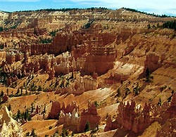 The view to the northeast from Sunrise Point captures
Boat Mesa and the Sinking Ship, set against the stark Pink Cliffs of the
Aquarius Plateau. Boat Mesa, capped by the resistant rock called "The
Conglomerate at Boat Mesa," rises above the hoodoos of Fairyland Canyon to
an elevation of 8073 feet. The view to the northeast from Sunrise Point captures
Boat Mesa and the Sinking Ship, set against the stark Pink Cliffs of the
Aquarius Plateau. Boat Mesa, capped by the resistant rock called "The
Conglomerate at Boat Mesa," rises above the hoodoos of Fairyland Canyon to
an elevation of 8073 feet.Geology
To the northeast of the mesa, the tilted rocks of the Sinking Ship impart
an impression of geologic unrest to viewers, and rightly so. These rocks
are a reminder of the tectonic activity that began 15 million years ago,
raising the Paunsaugunt Plateau to its present elevation and dragging
sections of rock along the faults, resulting in the tilt we see today.
Earthquakes in recent years remind us that Earth is constantly adjusting
and that activity along those faults continues, although in relatively
minor magnitudes.
The
Limber Pine at
Sunrise Point, roots exposed by erosion of the rim, serves as a reminder
of the resilience and ability of life to adapt to adverse conditions, and
also of the rapidity with which the scene before us is disappearing.
Geologists have calculated that the rim of the canyon is eroding at a rate
of two to four feet every century and that in approximately three million
years, Bryce Canyon will be gone forever. The hoodoos of Bryce Canyon's
main amphitheater appear as a snapshot in the rapid process of erosion on
the Paunsaugunt Plateau. This rapidly eroding land creates a harsh
environment for any living thing, and like this limber pine, all creatures
which live here, from people to animals to plants, must adapt to the
conditions in order to survive.
Nature
Ponderosa Pines dominate the forest above the rim and persist in pockets
as you descend into the Queen's Garden. Below the rim little shade is
available. In some hotter and drier places, bushes of Green-leaf Manzanita
are the tallest vegetation. Descending toward Tower Bridge on the
Fairyland Loop Trail takes you through the most barren region of the park
where Bristlecone
Pines are among the few plants that survive. In cooler and wetter
pockets of the Queen's Garden look for tall shrubs of Blue Elderberry and
flowers such as
Rock
Columbine. Sparse vegetation means little food, so here wildlife
species are limited to reptiles, rodents, and birds.
Trails
Sunrise Point serves as the trailhead for the easy to moderate Queen's Garden
Trail that descends into a section of hoodoos ruled by the Queen
Victoria hoodoo. This viewpoint also represents the end point for the Navajo Loop/Queen
Victoria combination, one of the most popular hikes in the Park. Just
to the north of this overlook, the Fairyland Loop climbs back up to the
rim continuing north to where it completes its 8-mile journey at Fairyland
Canyon overlook. For those who prefer shorter hikes, descending this
section of the Fairyland
Loop as far as the Tower Bridge and returning back up to Sunrise
point, offers a 3-mile "out & back." The Tower Bridge Hike
has a difficulty rating of moderate.
Services
Open April through October: Bryce Canyon General Store, Restrooms,
Drinking Water, Showers, Laundry, Snack Bar
|