|
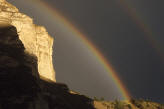
Zion is an ancient Hebrew
word meaning a place of refuge or sanctuary. Protected within the park's
229 square miles is a dramatic landscape of sculptured canyons and soaring
cliffs. Zion is located at the junction of the Colorado Plateau, Great
Basin and Mojave Desert provinces. This unique geography and the variety
of life zones within the park make Zion significant as a place of unusual
plant and animal diversity.
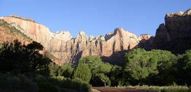
Zion is located along the edge of a region called the Colorado Plateau.
The rock layers have been uplifted, tilted, and eroded, forming a feature
called the Grand Staircase, a series of colorful cliffs stretching between
Bryce Canyon and the Grand Canyon. The bottom layer of rock at Bryce
Canyon is the top layer at Zion, and the bottom layer at Zion is the top
layer at the Grand Canyon. There is evidence
of 6,000 years of human occupation by Archaic, Ancestral Puebloans, (known
by archeologists as the Virgin Branch of the Kayenta Anasazi and Parowan
Fremont) Southern Paiutes and Mormon settlers who arrived in the 1860's.
•Zion
Canyon Scenic Drive
6 miles. Short drive along the canyon floor. Be prepared for hazardous
driving conditions during and immediately following storms. Icy spots
remain through the winter.
Open to private vehicles during the period
from November through March. Accessible the rest of the year via the Zion
Canyon Shuttle only. Rt. 9, which traverses the park from east to west, is
open year-round to private vehicles.
•Zion-Mt.
Carmel Highway
10 miles. Steep drive up switch–backs and through tunnels to Checkerboard
Mesa. See large vehicle restrictions on page 8. Be prepared for hazardous
driving conditions during and immediately following storms. Icy spots
remain through the winter.
•Kolob
Terrace Road
14 miles. Steep drive to the high country. Not recommended for long
vehicles. The road is plowed 14 miles north of Virgin, Utah. The rest of
the road is closed by snow.
•Kolob
Canyons
5 miles. Scenic drive skirting the Kolob ''finger canyons.'' The road is
plowed in winter but may be temporarily closed during storms or snow
plowing.
|