Stretched over 70 miles of
barrier islands, Cape Hatteras National Seashore is a fascinating
combination of natural and cultural resources, and provides a wide variety
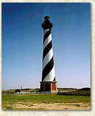
of recreational opportunities. Once dubbed the "Graveyard of the Atlantic"
for its treacherous currents, shoals, and storms, Cape Hatteras has a
wealth of history relating to shipwrecks, lighthouses, and the U.S.
Lifesaving Service. These dynamic islands provide a variety of habitats
and are a valuable wintering area for migrating waterfowl. The park's
fishing and surfing are considered the best on the east coast. Click the
"In Depth" button to the right for more detailed information.
Cape Hatteras stretches north to south across
three islands - Bodie, Hatteras, and Ocracoke. The islands are linked by
State Highway 12 - a narrow, paved road - and Hatteras Inlet ferry. Some
of the special natural and historical features that you can visit along
the way are described briefly below. The highway also passes through eight
villages that reflect the nearly 300-year-old history and culture of the
Outer Banks. The villages are not part of the park. For more information,
stop at the Whalebone Junction Information Center near the park's northern
entrance, or at any of the park visitor centers.
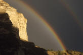
Cape Hatteras is at the ocean's edge, but
no well-defined boundary marks where the sea ends and the land begins.
Here land and sea work together in an uneasy alliance. They share many
valuable resources. But the sea fuels the barrier islands and there are
few places that escape its influence. On your visit take a moment to
discover this seaside kingdom.
Dwarfed, odd-shaped trees may catch your
eye. Severely pruned by salt-laden winds, these trees are just one example
of how the sea affects living things. Closer to the sea, shore birds
patrolling the beach for food are interesting to watch. Some catch small
fish or crabs carried by waves, while others probe the sand or search
under shells for clams, worms, and insects. On a hike through the maritime
forests you will leave the sea behind briefly. These woodlands of oak,
cedar, and yaupon holly grow on the island's higher, broader, somewhat
protected parts.
Bright red holly berries and wildflowers
offer a brush of color that enlivens the mostly green, brown, and blue
landscape. It is a landscape that is unusually peaceful - but not always.
Storms sometimes batter the islands with fierce winds and waves. Over the
years you can witness the retreat of the shoreline from these violent
attacks. For the tiny ghost crab, living on the beach in a wave-washed
underground burrow, survival is a matter of adaptation, adjusting to meet
the demands of the land and sea.
In the protected waters west of the
islands you can find excellent opportunities for crabbing and clamming.
The ocean also harbors a bounty of life, which includes channel bass,
pompano, sea trout, bluefish, and other sport fish. Wintering snow geese,
Canada geese, ducks, and many other kinds of birds populate the islands.
The best time for observing birdlife are during fall and spring migrations
and in the winter. Salt marshes are a source of food for birds and other
animals year-round. Here sound waters meet the marsh twice each day as
tides come and go, exchanging and replenishing nutrients. At the ocean's
edge, you are always on the threshold of a new experience.