|
Weather May Be Unpredictable - and a Source of
Great Beauty
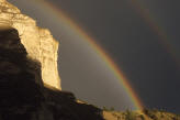
Weather plays a dramatic role at Crater Lake
National Park. Winter, especially, shapes the landscape; snow generally
begins to accumulate each year in October and doesn't melt in most places
until the following June. Summer weather is more predictable, with warm,
dry days, blue skies, and cool nights. Nevertheless, there may be days
even in August when the lake is completely obscured by clouds and fog.
Visitors to Crater Lake National Park should be prepared for any kind of
weather, any time of the year.
For current road and weather conditions updated
at 8am daily, call (541) 594-2211.
Summer Conditions
The weather in May and June
can vary from warm and sunny to snowy and foggy with poor lake visibility.
Temperatures may be as high as 65°F (18°C) or as low as freezing.
July, August, and September
are your "best bets" for dry, warmer weather. A typical daytime high
temperature during these three months is around 67°F (19°C), but can range
from 40°F to 80°F or more (4°C to 27°C). Temperatures cool off rapidly in
the evening, with a typical nighttime low around 40°F (4°C), while some
nights dip below freezing.
October usually
presents cool but sunny days and brings the start of winter snowfall by
mid-month.
Summer thunderstorms
occur from June through mid-September, bringing dramatic displays of
lightning and high winds. Boat tours, guided walks, and evening programs
may be canceled if lightning is present in the park.
Winter Conditions
From October to June,
Crater Lake National Park is a snow-covered wilderness. November through
April is assuredly snowy with poor
visibility and fair to poor driving conditions, but wonderful skiing and
snowshoeing opportunities. With snowfall still lingering on the ground in
early July, winter defines Crater Lake National Park more than any other
season.
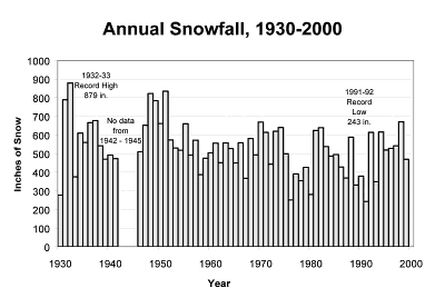
Snowfall averages 533 inches (1,350 cm) annually,
and by early spring, it is typical to have ten to fifteen feet (4 meters)
of snow on the ground. While snowfall is common in the Cascade Mountains,
Crater Lake National Park is one of the snowiest areas in the Northwest
where regular records are kept.
The National Park Service began recording weather
information at Crater Lake National Park headquarters in 1926. The winter
of 1932-1933 still holds the record for total snowfall in a single season,
with 879 inches (2,230 cm). In 1950, Crater Lake set a state record for
snowfall in a single calendar year, with 903 inches (2,294 cm).
The most snow ever recorded on the ground at Park Headquarters was 21 feet
(6.4 meters), on April 3, 1983.
Typical winter temperatures range from a high of
about 35°F (2°C) to an overnight low around 19°F
(-7°C).
Statistics
Crater Lake National Park Weather Statistics
National Weather Service records 1930-1999
| Month |
Maximum
Temp (°F) |
Minimum
Temp (°F) |
Rainfall
(inches) |
Snowfall
(inches) |
Snowdepth
(inches) |
| January |
34 |
18 |
10.7 |
106 |
81 |
| February |
35 |
18 |
8.4 |
88 |
105 |
| March |
37 |
19 |
8.0 |
87 |
120 |
| April |
43 |
23 |
4.9 |
45 |
113 |
| May |
50 |
28 |
3.4 |
21 |
78 |
| June |
58 |
34 |
2.3 |
4 |
24 |
| July |
69 |
41 |
0.8 |
0 |
1 |
| August |
69 |
41 |
0.9 |
0 |
0 |
| September |
63 |
37 |
2.1 |
3 |
0 |
| October |
52 |
31 |
5.2 |
22 |
2 |
| November |
39 |
24 |
9.7 |
64 |
17 |
| December |
34 |
19 |
11.4 |
93 |
49 |
All numbers are averages; individual
years may vary. Details may be found on the web site of the
Oregon Climate Service.
Why Does Crater Lake Get So Much Snow?
The major weather patterns at Crater Lake National
Park originate in the Pacific Ocean. Storm events originate in the north
Pacific and build in strength and moisture content over the ocean. Wind
patterns at these northerly latitudes move storms from the ocean to the
Pacific Northwest.
Over 100 inches (250 cm) of rain falls each year
on the Oregon Coast. After crossing the Coast Range, storm clouds descend
into the Rogue and Willamette Valleys, dropping about 30 inches (76 cm) of
rain. As storms move eastward, the high mountains of the Cascade Range
push the cool, moist air to elevations over 10,000 feet (3,000 meters) in
many places. As the air rises, it cools further. Water vapor in the air
condenses to form clouds, and snow crystals form within them. If there is
enough moisture in the clouds, the snow begins to fall. If the temperature
is warm enough, the snow melts before it reaches the ground and falls as
rain.
Crater Lake, like all of the Cascade Range, is
shaped by its winter snowfall. If you visit the park in summer, try to
imagine 16 feet (5 meters) of snow blanketing everything. Then envision
spreading phlox covering the roadsides. Without the snow, there would be
no phlox, no streams, and ultimately, no Crater Lake.
Snow Depth Statistics
|