|
How to Get to the North Rim
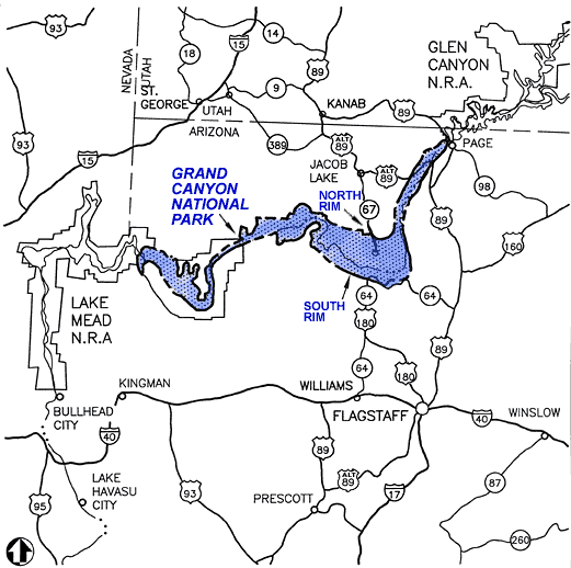
Grand Canyon National Park (NORTH
RIM) is located 30 miles south of Jacob Lake on Highway 67; the canyon
rim is an additional 14 miles south. Jacob Lake is located in northern
Arizona on Highway 89A, not far from the Utah border. Grand Canyon lies
entirely within the state of Arizona. Commercial airlines serve Phoenix,
Salt Lake City, and Las Vegas. There is limited air service into St George
Airport (north of the park in Utah) from Salt Lake City. There is no
public transportation to the North Rim other than the Trans Canyon Shuttle
(928-638-2820) from the South Rim. Visitor services and facilities inside
the national park on the North Rim are only open from mid May to mid
October. The road from Jacob Lake to the North Rim (Highway 67) is subject
to closure due to snow from mid-October to mid-May. You may wish to
view an area map.
The North Rim: An Overview
The North Rim Visitor Center is located adjacent
to the parking lot on Bright Angel Peninsula. Park and regional
information, maps, brochures, exhibits, and bookstore. Open mid May to mid
October, from 8am to 6pm, daily. Interpretive programs offered seasonally.
Public restrooms located in back of the building.
Scenic Viewpoints of the North Rim
The three developed viewpoints on
the North Rim offer a sense of looking across the expanse of the canyon,
rather than into its depths. Views of the Colorado River are rare and
distant. These descriptions may help you to plan your visit.
Point Imperial and Cape Royal are
reached via a winding scenic drive. The trip to both points, with short
walks at each and several stops at pullouts along the way, can easily take
half a day.
Point Imperial, the highest point
on the North Rim at 8,803 feet, overlooks the Painted Desert and the
eastern end of Grand Canyon. Here the canyon transforms as the narrow
walls of Marble Canyon, visible only as a winding gash, open dramatically
to become �grand.� Layers of red and black Precambrian rocks, not visible
at Bright Angel Point, add contrast and color. Part of the viewpoint is
accessible.
Cape Royal provides a panorama up,
down, and across the canyon. With seemingly unlimited vistas to the east
and west, it is popular for both sunrise and sunset. The sweeping turn of
the Colorado River at Unkar Delta is framed through the natural arch of
Angels Window. Look for the Desert View Watchtower across the canyon on
the South Rim. This popular viewpoint is accessible via a paved, level
trail.
It takes a bit of effort, and
four-wheel drive, to reach Point Sublime, the western-most of the North
Rim viewpoints. The rough, two-hour (one-way) trip to this remote point is
rewarded by a view that lives up to its name. Inquire about road
conditions and possible closures before heading out.
Most visitors make a stop at Bright
Angel Point, at the southern end of the entrance road. From the parking
area it is a short, easy walk to Grand Canyon Lodge and a classic view of
the canyon. This facility is wheelchair accessible. A paved, half-mile
(round-trip) trail leads from the lodge, out the spine of the ridge, to
the point. This trail is steep in places, with drop-offs and stairs, but
provides dramatic views into Roaring Springs and Bright Angel Canyons.
Havasupai Indian
Reservation
The Havasupai Indian Reservation is
in a large tributary canyon on the south side of the Colorado River. This
land lies outside the boundary and jurisdiction of the National Park
Service and is administered by the Havasupai Indian Tribe. The village of
Supai is accessible only by foot (an 8-mile hike) or horseback. Hiking is
by tribal permit only. Inquiries should be directed to Havasupai Tourist
Enterprises, P.O. Box 160, Supai, AZ 86435. (928) 448-2121 or (928)
448-2141 for the tourist office, (928) 448-2111 for lodging.
Hualapai Indian
Reservation
Grand Canyon West (located on the
south side of the Colorado River) is managed by the Hualapai Tribe. The
Hualapai Indian Reservation is located on the south side of the Colorado
River. This land lies outside the boundary and jurisdiction of the
National Park Service and is administered by the Hualapai Indian Tribe.
Inquiries should be directed to Hualapai Tribe, P.O. Box 538, Peach
Springs, Arizona, 86434, (928) 769-2216. They can provide you with driving
directions, as well as a rate structure for access to their lands along
the rim.
|