|
|
How to Get to the South Rim
Grand Canyon National Park (SOUTH
RIM) is located 60 miles north of Williams, Arizona (via route 64 from
Interstate 40) and 80 miles northwest of Flagstaff (via route 180). Grand
Canyon lies entirely within the state of Arizona. Commercial airlines
serve Phoenix, Flagstaff, and Las Vegas. There is limited air service into
Grand Canyon Airport (just south of the park) from Las Vegas and
elsewhere. Greyhound provides bus service to Flagstaff. Shuttle service
between Phoenix and Flagstaff, and between Flagstaff and Grand Canyon
Village is offered by Open Road Tours (800-766-7117), call for prices and
schedules. Amtrak provides rail service to Flagstaff with connecting bus
service to the canyon.
Grand Canyon Railway offers train service from Williams (for
additional information call: 1-800-THE-TRAIN). You may wish to
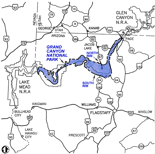
view an area map.
Approximate Driving Distances
- North Rim, Grand Canyon, AZ - 212 miles / 341
kilometers
- Take Highway 67 north to Highway 89Alt. Take
Highway 89Alt east to Highway 89. Take Highway 89 south to Highway 64.
Take Highway 64 west to the East Entrance on the South Rim - known as
Desert View.
- Flagstaff, AZ - 81 miles / 130 kilometers -
there are three ways to go:
- * Take I-40 west to Highway 64. Take Highway 64
north directly to the South Rim.
* Take Highway 180 west to Highway 64. Take Highway 64 north directly to
the South Rim.
* Take Highway 89 north to Highway 64. Take Highway 64 west to the East
Entrance on the South Rim - known as Desert View.
- Phoenix, AZ - 231 miles / 372 kilometers
- Take I-17 north to I-40. Take I-40 west to
Highway 64. Take Highway 64 north directly to the South Rim.
- Sedona, AZ - 119 miles / 192 kilometers
- Take Highway 89Alt to I-40. Take I-40 west to
Highway 64. Take Highway 64 north directly to the South Rim.
- Williams, AZ - 63 miles / 101 kilometers
- Take Highway 64 north directly to the South
Rim.
- Las Vegas, NV - 278 miles / 447 kilometers
- Take Highway 93 south to I-40. Take I-40 east
to Highway 64. Take Highway 64 north directly to the South Rim.
- Los Angeles, CA - 494 miles / 795 kilometers
- Take I-15 east to I-40. Take I-40 east to
Highway 64. Take Highway 64 north directly to the South Rim.
- Salt Lake City, UT - 510 miles / 821 kilometers
- Take I-15 south to Highway 14. Take Highway 14
east to Highway 89. Take Highway 89 south to Highway 89Alt. Take Highway
89Alt east to Highway 89. Take Highway 89 south to Highway 64. Take
Highway 64 west to the East Entrance on the South Rim - known as Desert
View.
- Denver, CO - 859 miles / 1382 kilometers
- Take I-25 south to I-40. Take I-40 west to
Highway 64. Take Highway 64 north directly to the South Rim.
- Albuquerque, NM - 412 miles / 663 kilometers
- Take I-40 west to Highway 64. Take Highway 64
north directly to the South Rim.
The South Rim: An Overview
Day-use visitors should expect
traffic congestion and parking problems, particularly in summer. The least
crowded time is November through February. However, winter weather is a
major consideration when planning a trip during these months.
The South Rim of Grand Canyon
averages 7000 feet/2134 m above sea level. Visitors with
respiratory or heart problems may experience difficulties. All walking at
this elevation can be strenuous.
How to See the Canyon
Canyon View Information Plaza is
the park's visitor facility. Here you will find the visitor center (Canyon
View Center), a large bookstore, and ample restrooms, all within a short
walk of Mather Point. Because this facility was designed as the terminus
for a mass transit system that is not yet operating, you cannot drive to
it. Park your car and ride the
free shuttle or walk the short trail from Mather Point.
There are many overlooks accessible
by car that offer spectacular views of the canyon. Desert View Drive
(Highway 64) follows the canyon rim for 26 miles/42 km east of
Grand Canyon Village to Desert View - the east entrance to the park.
Desert View Drive is open to private vehicles throughout the year. Hermit
Road follows the rim for 8 miles/13 km west from Grand Canyon
Village to Hermits Rest. Hermit Road is closed to private vehicles much of
the year, but the park runs a
free shuttle bus to provide transportation to overlooks.
A hiking trail, known as the Rim
Trail, follows the rim from Pipe Creek Vista to Hermits Rest. The section
of the Rim Trail between Pipe Creek Vista and Maricopa Point is paved, and
mostly wheelchair accessible. Unpaved portions of the trail, between
Maricopa Point and Hermits Rest, are narrow and close to the edge.
Bicycles are not permitted on the Rim Trail.
Yavapai Observation Station at
Yavapai Point offers panoramic views of the canyon, including the Colorado
River and Phantom Ranch. Yavapai Observation Station is open all year.
For viewing and photographing the
canyon, the best light is early or late in the day. Mid-day sun tends to
flatten the view and soften the colors. Remember that days are short in
the winter and long in the summer. If you plan to see the canyon at
sunrise or sunset, it is recommended that you be on the rim at least an
hour before.
The Colorado River flows along the
bottom of the canyon, 5000 feet/1524 m below the rim. Because of
the enormous depth of Grand Canyon, the river is visible only from certain
viewpoints. It is a two-day hike to the river and back from the South Rim.
It's a longer trip from the North Rim. It is possible to drive to the
Colorado River at Lees Ferry (near Marble Canyon, Arizona), a 2.5 hour
drive (one way) from the South Rim. Lees Ferry marks the official
beginning of Grand Canyon.
Havasupai Indian
Reservation
The Havasupai Indian Reservation is
in a large tributary canyon on the south side of the Colorado River. This
land lies outside the boundary and jurisdiction of the National Park
Service and is administered by the Havasupai Indian Tribe. The village of
Supai is accessible only by foot (an 8-mile hike) or horseback. Hiking is
by tribal permit only. Inquiries should be directed to Havasupai Tourist
Enterprises, P.O. Box 160, Supai, AZ 86435. (928) 448-2121 or (928)
448-2141 for the tourist office, (928) 448-2111 for lodging.
Hualapai Indian
Reservation
Grand Canyon West (located on the
south side of the Colorado River) is managed by the Hualapai Tribe. The
Hualapai Indian Reservation is located on the south side of the Colorado
River. This land lies outside the boundary and jurisdiction of the
National Park Service and is administered by the Hualapai Indian Tribe.
Inquiries should be directed to Hualapai Tribe, P.O. Box 538, Peach
Springs, Arizona, 86434, (928) 769-2216. They can provide you with driving
directions, as well as a rate structure for access to their lands along
the rim.
|